Tofino to Shark Creek Falls

The Evening Before the Launch
I spent the evening before my launch at the Dolphin Motel just outside Tofino. As always it was a pleasant stay and I enjoyed the interaction with one of the owners, “The Dolphin lady.” I’ve stayed at the Dolphin Motel several times now and I still don’t know her name. I’ve just always called her “Dolphin” and so we’ll go with that. Anyone that has stayed here, knows her. If you’re looking for a comfortable and economical stay in the Tofino area, I highly recommend the place.http://www.dolphinmotel.ca/

Day 1 – July 14th – Fog Launch, Miscalculations and Turbulent Waters
I successfully launched with all my gear stowed from the Tofino kayak ramp around 7:30 am. There was fog but not to the point that I thought it would jeopardize navigation. I was proven wrong when I became confused between the entrances to Maurus Channel and Lemmens Inlet. Maurus Channel is for the most part protected from the winds and the open ocean on the east side of Vargas Island. It was my intended route but after becoming disoriented I decided to follow the exposed west side of Vargas Island through the turbulent LaCroix Group of islands. (Yes, it’s time for a handheld GPS.)

Launching into the early morning fog from Tofino Kayak Launch.

Beached and taking a break in a protected cove on the west side of Vargas Island.
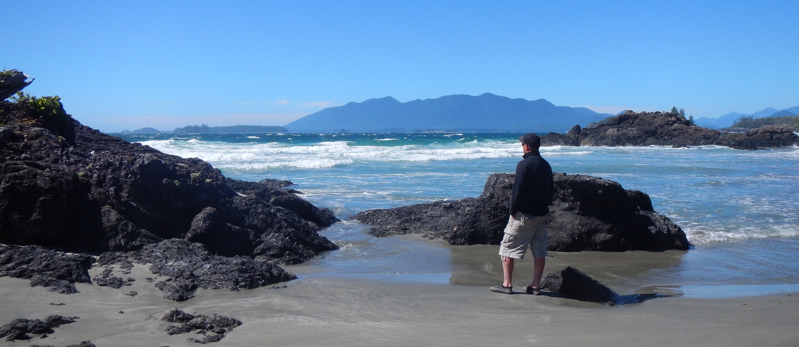
As I paddled alongside Ahous Bay I was relieved to see Blunden Island on the horizon, a previous camping place, though it was not my intention to do so this time. With the miscalculation in routing earlier, I had decided to try to make it to Dick and Jane’s beach on the northern end of Vargas Island, but I was prevented from doing so when I encountered very turbulent water and dangerous breakers just north of Ahous Bay. I decided to turn west and head the 2 km’s to Blunden Island and call it a day. The area between Vargas Island and Flores Island is a dangerous crossing even in optimal conditions, leaving a paddler exposed to the unpredictability of the open ocean.

Landing on Blunden Island, about a 20 km paddle from Tofino and relieved to be off the turbulent water.

Unfortunately I forgot the pole for the top part of my bivvy sack so I had to improvise with a trusty piece of driftwood. It worked just fine.

Blunden Island campsite.
Day 2 – July 15th – Fog and the Dangerous Crossing
After a comfortable night on Blunden Island I woke up to heavy fog, unable to see Vargas Island only 2 km’s away. I suspected treacherous conditions on the open water between Vargas Island and Flores Island. I pondered the notion of making the crossing but decided against it. (The recent training I received from Paddle Canada and Comox Valley Kayaks along with just my own experience and intuition certainly came in handy.) I was able to call Tofino Water Taxi and arrange for them to pick me up at 2:00 pm and take me to Ahousaht on the south end of Flores Island. I was disappointed that I couldn’t continue on without assistance but once I got on the taxi and made the crossing I was reassured that I made the right choice as the conditions were harsh. Even the guide from Tofino Water Taxi, Brandon, a lifelong resident of Tofino, commented that he couldn’t imagine trying to make the crossing that day in a kayak.

The potential crossing between Blunden Island and Flores Island, less than optimal given the fog, wind, breakers and swell.

Getting picked up by Tofino Water Taxi.

Departing Blunden Island with the help of Tofino Water Taxi.
Once arriving and being dropped off at Ahousaht the sun was out and there wasn’t a cloud in the sky, only a thick line of fog to the south where I had come from. I paddled the 15 km’s to Obstruction Island at the north end of Millar Channel with the wind at my back and the tide pushing me along. The campsite was rather difficult to find or perhaps I wasn’t expecting what it was, a jagged rocky outcrop but in a very tranquil and protected cove. I made camp, relaxed and rested easy until I heard what I believe was a cougar scream in one of the adjacent mountains.

Obstruction Island campsite, campsite choices are very few and there was very little firewood. I collected what I could find but for the sole purpose of warmth and not pleasure. I didn’t make a fire on the first night just in case I needed the warmth for later on.

Flat ground was hard to find but this proved to be a pretty idyllic choice. Every so often a Sea Otter would pop up to watch me.

Obstruction island campsite.
Day 3 – July 16th – Morning Fog, the Black Bear, a Broken Paddle and Shark Creek Falls
After enjoying a warm and sunny afternoon the day before I was yet again plagued by morning fog and dampness. It wouldn’t be until noon that the fog lifted. I started paddling south down Millar Channel at around 6:30 am; the waters were calm but I hugged the shoreline due to the fog. A few hours later I approached Shark Creek Falls. (maybe state the exact hours it took to reach the falls).

The 5 km paddle south down Millar Channel to the entrance of Shark Creek Falls.

Entrance to Shark Creek Falls at low tide.
Unbeknownst to me, one can only access Shark Creek Falls by kayak at high tide. There’s little information available about these waterfalls. I got stuck on the creek bed and had to carry my boat back out to the entrance. I was glad I did because a Black Bear was foraging for food on a beach nearby.

Shark Creek Falls were very difficult to compose and photograph due to their location and general contrast surrounding the area. Instead I got a trade off and a chance to photograph this Black Bear while I waited for the tide to rise.

After spending what time I did have on the high tide at the waterfalls I headed back in choppy water to my Obstruction Island campsite for dinner and a fire.
Finally, the tide was up high enough at about 1:00 pm and I could access the waterfalls.

After spending what time I did have on the high tide at the waterfalls I headed back in choppy water to my Obstruction Island campsite for dinner and a fire.

These freeze dried dinners are great, Lasagna was on the menu for night # 3.

Obstruction Island campsite and campfire, burning what little wood I had been able to find.
Day 4 – July 17th – The Paddle back to Ahousaht
I woke at about 5:30 am, burnt a little bit of the leftover firewood that I had and packed up pretty quickly and was able to launch from Obstruction Island at 6:30 am. The water was as smooth as silk and it only took me about 3 hours to paddle the 15 km on the outgoing tide down Millar Channel.

Paddling down Millar Channel. My echo would carry for at least 6 or 7 seconds as I called out to the surrounding mountains.

Landing at Ahousaht and waiting for Tofino Water Taxi to come get me.
Hot Springs Cove still eludes me but I will get to the springs one day. Allowing myself only 3.5 days to make a 60 km journey just wasn’t enough due to conditions and tides. Next time I will allow for 7 days. All in all, I did get the better part of 50 km of paddling in and thoroughly enjoyed the serenity and magic that Clayoquot Sound offers.
Enjoyed reading about your trip.
Thanks Logan and thanks for taking the time to do so.
I’m living vicariously through your Adventures!
Wow ! What a trip ! Thanks for sharing.
Thanks Fred!
Hey, great story about your trip..I enjoyed the read! Oh, and of course, the great pictures.
Thank you sir!
What a great trip Martin, and the perfect summer to be on the west coast. Love your site.
Thanks Adele!
I launch my boat every time I go out from the same spot you used!
It’s the best spot! Any tips on best locations / photographing coastal Wolves over that way?
I live vicariously through your Adventures! Very Inspirational.
Thank you Cindy! These experiences for me are incredibly rewarding and will resonate with me for a lifetime.
I always, always look forward to viewing and reading your water adventures!
Thank you sir!! 🤗