Exploring Side Bay

Side Bay is located on Northwest Vancouver Island, north of Brooks Peninsula and pretty much right beside Lawn Point Provincial Park. It is accessible via logging road from Port Alice, approximate driving time is 4.5 hours from the Comox Valley. It’s 3 hours of pavement and then 1.5 hours of logging road. There’s lots of signs on the logging road to point you in the right direction and it’s in really good shape – much better than say the road to Bamfield in comparison.

Day 1
The drive up island was good, I left Courtenay at 4:00 pm and arrived in Port Alice at 7:00 pm. Don’t plan on getting any fuel, last minute supplies or a bite to eat. The folks in Port Alice truly are on “island time.” Everything, such as what there is closes at 6:00 pm or more likely 3:00 pm. Fortunately someone was able to call the person that tends the fuel station and they were glad to help. I did manage to find a restaurant called “Pizza Place.” A small pepperoni and cheese took an hour and there was much more crust than any cheese or pepperoni. Either way, I was glad to have it and started making my way on the logging road to Side Bay, leaving Port Alice at 8:00 pm. I was a bit uncertain, as I have never driven in this area before but as mentioned there’s lots of signs pointing you in the right direction and the road is in great shape. Along the way I counted 17 signs of Black Bear scat. I also saw a large Black Bear running full out along the road in front of me, just before I arrived at Side Bay at 9:30 pm. No, you can’t outrun a Bear and seeing this animal kicking up dust was a great reminder of that.
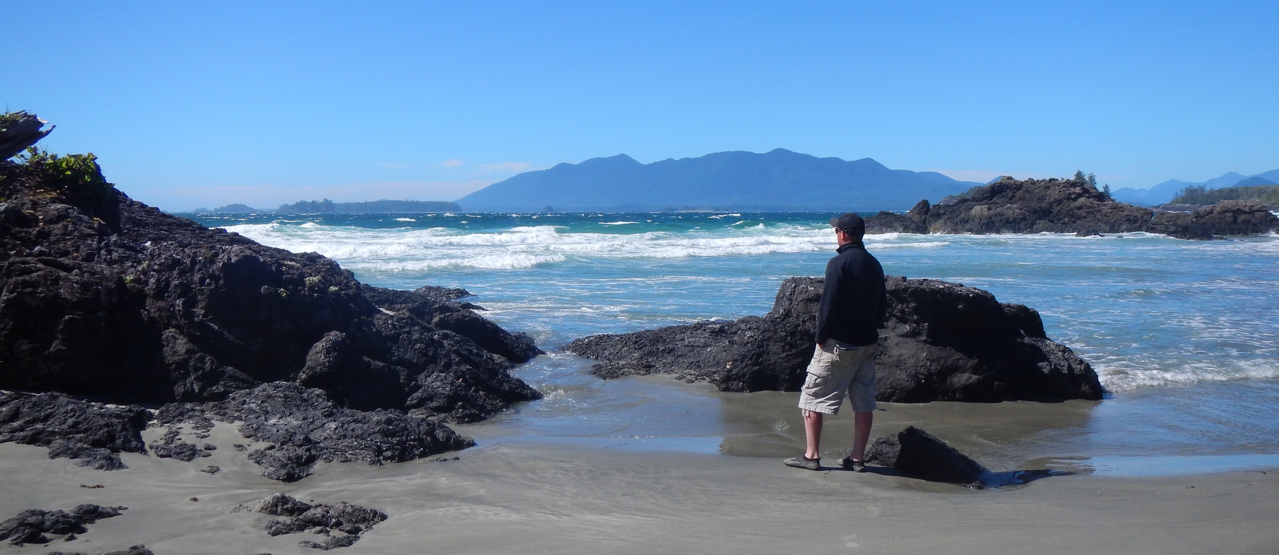
I set up my camp at Side Bay just as the moon was beginning to rise over Brooks Peninsula. A few other campers were further down the beach but it really did feel like I was alone.

It’s been very dry both in British Columbia and Vancouver Island, hence the recent fire ban on the island outside of “the fog zone.” I was able to build a small fire below the high tide line on the beach and sat beside it until about 12:30 am before settling in for the night.
Day 2
Instead of getting out on the water early I decided to stay the day at Side Bay. Considering I arrived late the night before I wanted to spend the day combing the expansive beach, studying the waters, creating images and reading my book. It was nice to just relax and not really have anywhere to be. A very creative person had left some “rock art” behind which was fun to see.


Day 3
I launched from Side Bay late in the morning, around 10:30 am at low tide. A note to those that paddle solo. You’ll need a cart for the long walk down the beach. The surf tends to be a lot lower at low tide than when the tide is up which is why I chose to launch when the tide was at it’s lowest.

There was some gentle swell, light wind but it was warm and sunny. I counted 4 Sea Otters along the way as I Paddled towards Mayday Island. Although not a designated British Columbia Marine Trails Campsite bcmarinetrails.org John Kimantas mentions a beach on Mayday Island on page 83 of the BC Coast Explorer and Marine Trail Guide that I figured could serve as a camp if I needed it to be. I was glad to be informed about this for later. My first stop was at Keith River Pocket Beach to begin completing 1 of 3 site condition field reports I had planned for the day for the British Columbia Marine Trail Network. Completing these assessments are a lot of fun and a great way to contribute to the various initiatives undertaken by BCMTN. If you’re staying at any designated British Columbia Marine Trail Network Campsite, please take the time to complete a site condition field report: bcmarinetrails.org/…w-to-help/stewardship Reports are needed for these sites as a part of the North Vancouver Island Circle Route: drive.google.com/…Bf_Y3JIQ05wQjV6bmc/view
Keith River Pocket Beach – Site Condition Field Report #1
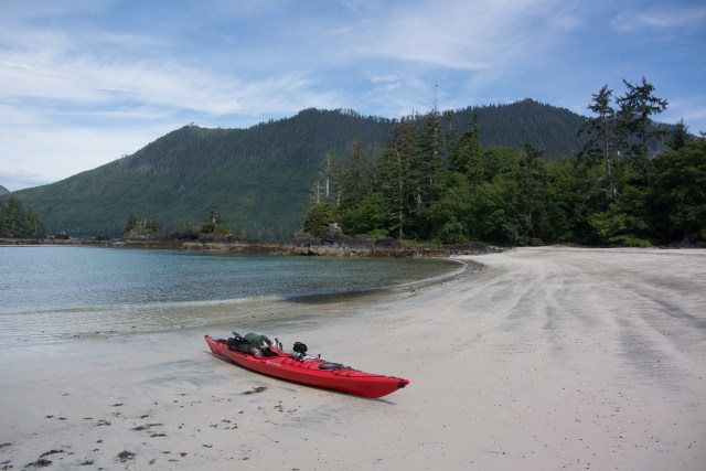


This is an expansive sand beach about 3.5 km from Side Bay, easy landing with camping on the beach and just under the treeline. Cougar, Wolf and Black Bear are plentiful in the area, so remember to keep a clean camp and practice leave no trace principals.
Keith River Site 3 – Site Condition Field Report #2


This is a smaller sand beach, easy landing with camping on the beach and just under the treeline. Heavy driftwood may impede on some beach camping. Of the 3 beaches, this is the only one that didn’t have recent signs of wildlife in the form of Black Bear tracks. It’s about 500 m from Keith River Pocket Beach.
Keith River Site 4 – Site Condition Field Report #3


On this Beach there were very recent signs of Black Bear, likely within the last 12 hours or less. I contemplated spending the night here until I saw the tracks.
Mayday Island
After completing my final site condition field report I noticed the wind start to pick up and what appeared to be a system forming over Brooks Peninsula. The water started to become choppy too. My original destination was Heater Point but it was getting later in the day and I thought it would be best to turn around. Not wanting to stay on the beaches with recent signs of wildlife, I opted to make camp at Mayday Island. It turned out to be a good decision not to head to Heater Point as it began to howl wind and rain at about 6:30 pm.


I hunkered down in my tent for the night, read my book and fell asleep around 11:30 pm.
Day 4
I broke camp at 5:30 am and was on the water at 6:20 am. The heavy rain stopped earlier. There was still a light drizzle, it was windy and the waters were quite choppy as I crossed back over to Side Bay. I was glad to get off the water. I landed at Side Bay at very low tide. Just as I got out of my kayak, 1 meter waves crashed on the beach behind me. So much for my claim for low surf at low tide.

Side Bay is a very picturesque area, it’s out there but with some effort it is accessible. Waking up each morning and having views of the infamous Brooks Peninsula in your backyard is inspiring. It’s a great launching point for destinations there and in the surrounding area. A good resource before heading out is contacting the Port Alice Visitor Center, they can update you on road conditions and so forth: portalice.ca/visitors/visitor-centre
I enjoyed the read. Thanks Martin
You bet John, thanks for giving it a gander! 😊👍
We were there for Canada day – great area all to ourselves. I left an 8 pack of Lucky in the creek beside your campsite but I guess it was already gone 🙂
Looking forward to taking my kayak next time and exploring out to Lawn Point.
I bet the lucky didn’t last long! Haha! Be sure to explore the Keith River area by kayak too! Beautiful beaches!
It’s a spectacular location!